
Stretching out into the North Atlantic like an outstretched arm, the Snæfellsnes Peninsula packs an almost absurd amount of Iceland into a relatively small area. Glaciers, volcanoes, lava fields, black pebble beaches, golden sand shores, sea cliffs teeming with birdlife, and tiny fishing villages clinging to the coast — it’s all here, compressed into roughly 90 kilometres of western shoreline. Locals sometimes call it “Iceland in miniature,” and it’s hard to argue with that.
Where It Sits and How to Get There
Snæfellsnes lies in western Iceland, its southern coast facing the open Atlantic and its northern shore looking across Breiðafjörður bay. Reykjavík is about three hours’ drive to the southeast, making the peninsula comfortably reachable as a day trip from the capital — though spending longer is always a good idea. The small town of Borgarnes, a natural stopping point along the way, marks the transition from the settled southwest into something wilder and more sparsely populated.
The Glacier That Started It All
The peninsula’s western tip is dominated by Snæfellsjökull, a glacier-capped stratovolcano that rises to 1,446 metres. It’s the landmark that defines the region — visible on clear days from Reykjavík, over 100 kilometres away. Jules Verne famously chose it as the entry point for his 1864 novel Journey to the Centre of the Earth, and there’s something about the mountain’s solitary, ice-clad silhouette that makes that choice feel less like fiction and more like reasonable speculation. Snæfellsjökull sits at the heart of a national park that protects the surrounding lava fields, coastline, and craters.
A Coastline of Contradictions
What makes Snæfellsnes so visually striking is how dramatically the coastline shifts character from one stretch to the next.
At Ytri Tunga, the sand is golden — a genuine oddity in a country where volcanic geology has turned most beaches black. Seals are regular visitors here, hauling themselves onto the rocks with the air of locals who got there first.
A short distance away, Djúpalónssandur couldn’t be more different: a brooding, windswept shore of smooth black lava pebbles, sometimes called lava pearls. Sitting on the beach are four ancient lifting stones of graduated weight — Amlóði (23 kg), Hálfdrættingur (54 kg), Hálfsterkur (100 kg), and Fullsterkur (154 kg). Centuries ago, any man who couldn’t raise the 54-kilogram stone onto a waist-high ledge was deemed too weak to crew one of the fishing boats that launched from nearby Dritvík. The stones are still there. People still try. The sea still wins most arguments around here.
At Arnarstapi, the Atlantic has been chiselling away at basalt cliffs for millennia, leaving behind arches, stacks, and stumps. The most famous is the Gatklettur arch, framing open ocean through a window of dark rock. These cliffs are also prime nesting territory for fulmars, kittiwakes, shags, puffins, and Arctic terns — the noise and activity during breeding season is something else entirely.

Volcanic Landscape Inland
Step away from the coast and the terrain shifts to lava fields, moss-covered rock, and volcanic craters that tell a story stretching back thousands of years.
Hólahólar is a cluster of craters, the largest of which has collapsed on one side to form a natural amphitheatre. A farm once operated here but was abandoned in 1880. According to Icelandic folklore, the Huldufólk — the hidden people — moved in after the humans moved out. Whether you believe that or not, the place has an atmosphere that’s hard to shake.
Nearby Saxhóll is a crater formed somewhere between 3,000 and 4,000 years ago when molten lava met groundwater. A metal staircase of 396 steps climbs gently to the rim, 109 metres up, where the view opens out across the Atlantic, the glacier, and the surrounding lava fields in every direction.
Beneath the surface, Vatnshellir is a lava tube roughly 8,000 years old — a 200-metre tunnel left behind when a river of molten rock cooled on the outside and drained from within. Mineral deposits of iron, sulphur, and copper streak the walls in reds, yellows, and greens, making it far more colourful than you’d expect from a hole in the ground.
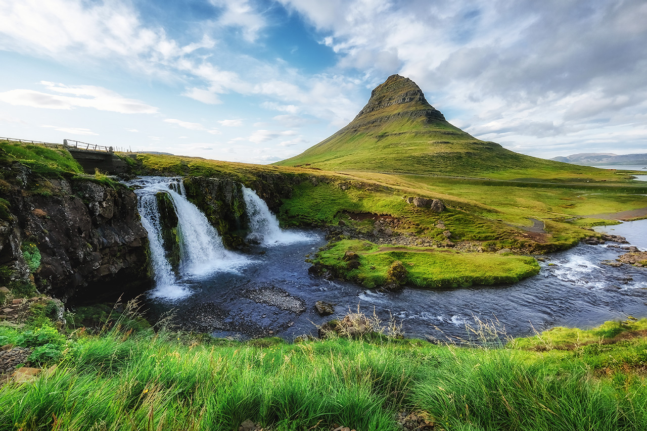
Kirkjufell: The Mountain Everyone Recognises
On the peninsula’s north coast, near the town of Grundarfjörður, Kirkjufell has become one of the most photographed mountains in Iceland. Its steeply ridged, almost pyramidal shape — the name translates as “Church Mountain” — is distinctive enough on its own, but the waterfall cascading in front of it turns the whole scene into something that barely looks real. It’s appeared in films, TV series, and on the cover of countless travel guides, and yet it still manages to feel surprising in person.
The Fishing Villages
Snæfellsnes is sparsely populated, but a handful of small coastal settlements give the peninsula its human dimension.
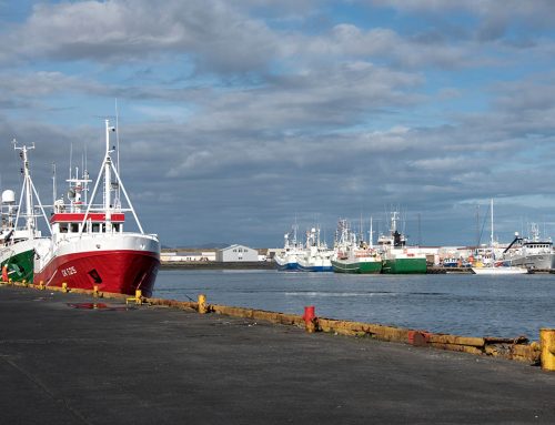
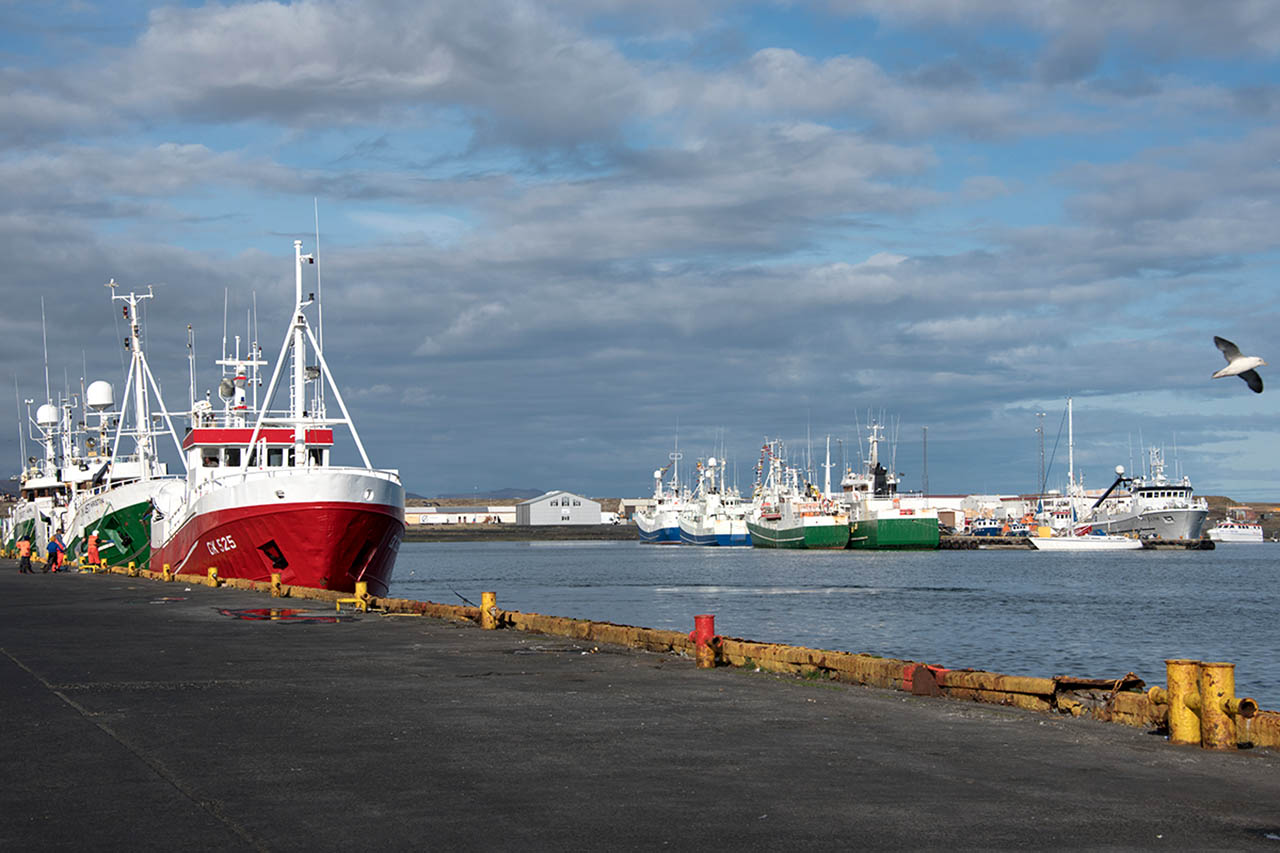
Ólafsvík, on the north coast, is a working fishing village where trawlers still come and go from the harbour — a reminder that for many Icelanders, the sea remains a livelihood, not just a backdrop.
Stykkishólmur, further east, is the largest town on the peninsula and has a more developed character. Its compact centre holds a collection of well-preserved old buildings, including the Norwegian House, which dates to 1828 and is considered one of the oldest structures in Iceland. The town’s harbour is also the departure point for ferries heading north to the remote Westfjords.
For anyone curious about the more uncompromising side of Icelandic food culture, the Bjarnarhöfn Shark Museum offers the chance to taste hákarl — fermented Greenland shark that’s been hung and dried until it crosses the line from inedible to technically edible. The smell alone is an experience. Whether you swallow is entirely up to you.
The Seasons Shape Everything
Snæfellsnes is a year-round destination, but the peninsula wears each season very differently.
Summer brings long daylight hours, milder temperatures, and the best statistical chance of clear skies — conditions that let you appreciate the full sweep of the coastal views. It’s also peak season, so expect more company at popular stops. Notably, on 12th August 2026, the peninsula will lie directly in the path of a total solar eclipse, with over two minutes of totality — a rare event that’s already drawing attention.
Winter transforms the landscape with snow and ice, adding a stark, almost monochrome beauty to the volcanic terrain. Weather can be fierce and unpredictable, but clear nights open the possibility of seeing the Northern Lights rippling above the glacier. Fewer visitors mean a greater sense of isolation — which, depending on your temperament, is either the whole point or a reasonable concern.
Spring and autumn are transitional and unpredictable. Spring brings lengthening days and softening weather without the summer crowds. Autumn moves fast in Iceland — winter doesn’t wait around — but the fleeting colour changes and low-angle light can make the peninsula feel like it was designed for photographers.
Why It Matters
Iceland’s south coast and Golden Circle get the lion’s share of attention, and fairly so — the geysers, waterfalls, and glacial lagoons are extraordinary. But Snæfellsnes offers something those places don’t: the feeling of standing at the edge of things. The peninsula is where Iceland meets the open Atlantic, where volcanic land gives way to ocean, and where centuries of fishing culture have left a quiet mark on a dramatic landscape.
It’s close enough to Reykjavík to visit in a day, but remote enough to feel like a different country entirely. For anyone wanting to understand what Iceland is beyond the postcard shots, this is a very good place to start.

